 Link preview
My $250 mobile robot uses 4 smartphones as a budget LiDAR alternative. Works surprisingly well, but I hit a depth scaling snag.
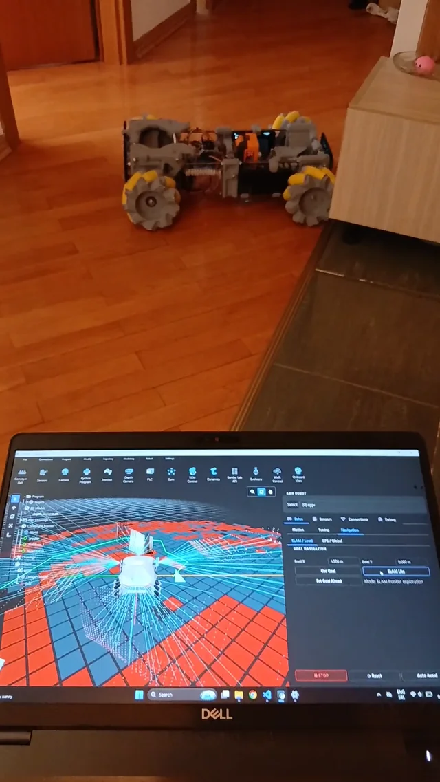
Hey r/robotics, Wanted to share my latest budget mobile robot build. The goal was to keep it under $250, so instead of buying an expensive LiDAR setup or dedicated depth cameras, I rigged up 4 cheap smartphones to stream video data. I’m running the streams through Depth Anything v3 (DA3) to estimate the depth maps, and honestly, for a "poor man's LiDAR," it’s going incredibly strong. The issue I'm running into: Since DA3 outputs relative/monocular depth maps, I’m struggling with absolute scale calibration. Right now, the robot thinks walls are further away than they actually are. It knows where the obstacles are, but the metric distance is skewed because DA3 doesn't have real-world depth data. I want to fix this by adding a hardware sensor to act as a "ground truth" anchor to correct and scale the DA3 depth data in real-time. Has anyone here tried using a ToF (Time-of-Flight) sensor or an Ultrasonic sensor to handle this kind of depth correction? Would a single-point distance reading be enough to dynamically scale the relative map, or is there a better way to do it? If anyone is curious about the hardware or wants to check out the setup, I put the specs and documentation here and the chassis CAD files here. Looking forward to hearing your thoughts on how to fix the depth scaling! submitted by /u/ganacbicnio [link] [Kommentare] reddit.com · reddit.com
Link preview
My $250 mobile robot uses 4 smartphones as a budget LiDAR alternative. Works surprisingly well, but I hit a depth scaling snag.
Hey r/robotics, Wanted to share my latest budget mobile robot build. The goal was to keep it under $250, so instead of buying an expensive LiDAR setup or dedicated depth cameras, I rigged up 4 cheap smartphones to stream video data. I’m running the streams through Depth Anything v3 (DA3) to estimate the depth maps, and honestly, for a "poor man's LiDAR," it’s going incredibly strong. The issue I'm running into: Since DA3 outputs relative/monocular depth maps, I’m struggling with absolute scale calibration. Right now, the robot thinks walls are further away than they actually are. It knows where the obstacles are, but the metric distance is skewed because DA3 doesn't have real-world depth data. I want to fix this by adding a hardware sensor to act as a "ground truth" anchor to correct and scale the DA3 depth data in real-time. Has anyone here tried using a ToF (Time-of-Flight) sensor or an Ultrasonic sensor to handle this kind of depth correction? Would a single-point distance reading be enough to dynamically scale the relative map, or is there a better way to do it? If anyone is curious about the hardware or wants to check out the setup, I put the specs and documentation here and the chassis CAD files here. Looking forward to hearing your thoughts on how to fix the depth scaling! submitted by /u/ganacbicnio [link] [Kommentare] reddit.com · reddit.com
Hey r/robotics, Wanted to share my latest budget mobile robot build. The goal was to keep it under $250, so instead of buying an expensive LiDAR setup or dedicated depth cameras, I rigged up 4 cheap smartphones to stream video data. I’m running the streams through Depth Anything v3 (DA3) to estimate the depth maps, and honestly, for a "poor man's LiDAR," it’s going incredibly strong. The issue I'm running into: Since DA3 outputs relative/monocular depth maps, I’m struggling with absolute scale calibration. Right now, the robot thinks walls are further away than they actually are. It knows where the obstacles are, but the metric distance is skewed because DA3 doesn't have real-world depth data. I want to fix this by adding a hardware sensor to act as a "ground truth" anchor to correct and scale the DA3 depth data in real-time. Has anyone here tried using a ToF (Time-of-Flight) sensor or an Ultrasonic sensor to handle this kind of depth correction? Would a single-point distance reading be enough to dynamically scale the relative map, or is there a better way to do it? If anyone is curious about the hardware or wants to check out the setup, I put the specs and documentation here and the chassis CAD files here. Looking forward to hearing your thoughts on how to fix the depth scaling! submitted by /u/ganacbicnio [link] [Kommentare]
Comments